The Diversity of Bengal
The Territories under the Lieutenant-Governor of Bengal
“The territories under the Lieutenant-Governor of Bengal, sometimes called the Lower Provinces, lay1 between under longitude 82° and 97°, the most westerly portion being Bhokar in the Chutia Nagpur Commissionership, and the most easterly point, that of Sadia in Upper Asam, and between latitude 20° and 28°, the most southerly point being the Chilka Lake in Orisa, and the most northern points Tirhut and Sadia. These territories were bounded to the north by Nipal, Sikkim, Bhutan, and the lands occupied by the Aka, Miri, and Mishmi tribes; to the east, by Burmah; to the south by Burmah, the Bay of Bengal, and the Madras Presidency; to the west, by the Central Provinces, Rena, and the North-Western Provinces. The area of these territories was estimated at 280,200 square miles, the population at sixty-five millions. The races constituting this population are more various than those of any other part of India. The Hindu population contains all the castes of the Hindus, with many subdivisions. Of these, the Kayaths, proceeding from a Kshatriya father and a Sudra, or low-caste, mother, are the most numerous. These supply the clerks and copyists, of whom Bengal is so prolific. The Brahmans trace their origin to Brahmans who immigrated from Kanauj when that famous city felt the tyranny of the Muhammadan invader. The Muhammadan population, which is most numerous in the south-eastern parts of Bengal, consists of descendants from Afghans and a large number of converts from low Hindu, Arakanese, and aboriginal tribes. Aboriginal tribes, who cling to their old customs, are chiefly met with in the mountainous parts of Asam, in eastern Bengal, in Orisa, in Chutia Nagpur, and in the Rajmahall hills. Immigrants from these tribes are freely employed in the tea districts of Asam. The languages spoken are as various as the populations. In Bengal there is Bengali with its several dialects; in Orisa, Uriya; in Asam, Asamese; in Bihar, Hindi, and Hindustani. I am unable to enumerate all the languages spoken by the aborigines.
Modern Nomenclature of these Territories
In the time of Clive, these territories were spoken of as the provinces of Bengal, Bihar, and Orisa; but at the present day, this division is purely geographical. The territories under the Lieutenant-Governor of Bengal were, in 1857, divided into divisions or commissionerships, and these again were subdivided into districts, that is, every Commissioner of a division had under his control a certain number of districts under an officer responsible primarily to himself. These districts combined went to form the division.
Names and numbers of the Divisions and Districts
In 1857 the number of divisions was eleven.
They were Orisa, containing three districts, Katak, Puri, and Baleshwar; Bardwan; Western Bengal, with its five districts, Bardwan, Bankura, Birbhum, and Haurah, and Midnapur; the Presidency, with Calcutta and the twenty-four parganahs, Nadia, and Jessor; Rajshahi, with its seven districts, Murshidabad, Dinajpur, Malda, Rajshahi, Rangpur Bagura, and Pabna; Koch Bihar, with Darjiling, Jalpaiguti, and the tributary state of Koch Bihar; Dhakah, with its six districts, Dhakah, Faridpur, Bakirganj, Maimansingh, Silhat, and Kachhar; Chitragaon, with Chitragaon and the hill tracts, Bhalua (Noakhali), Tiparah and Hill Tiparah; Asam, with its nine districts, Goalpara, Kamrup (Gauhatti), Durang, Naugaon, Sibsagar, Lakkhimpur, the Garo hills, the Khasia and Jaintia hills, the Naga hills; Patna, or, more correctly, Western Bihar, with its six districts, Patna, Gaya, Shahabad, Saran, Champaran, and Tirhut; Eastern Bihar, with Munger, Bhagalpur, Purnia, and the Santal parganahs; Chutia Nagpur (the south-west frontier Agency), with Lohardaga, Hazaribagh, Singhbhum, Manbhum, and certain tributary Mahalls, such as Bhokar, Korea, Sirguja, Udaipur, Jashpur, Gangpur, Bonai, Sarunda, and others equally small, covering altogether an area of 12,881 square miles.”
(From Kaye’s and Malleson’s “History of the Indian Mutiny of 1857–8, Volume 6.”)
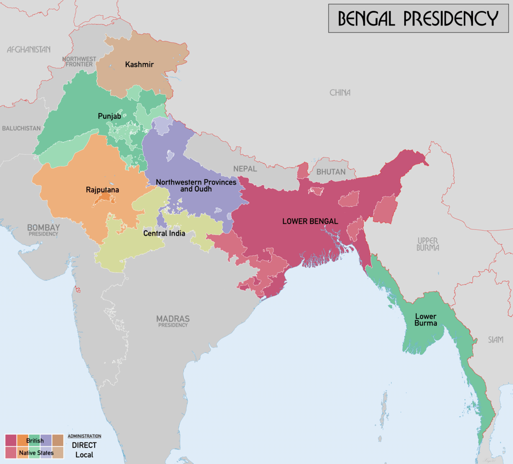
By far the most diverse area of British India was the Bengal Presidency. At the very pinnacle of its territorial jurisdiction, it covered large swathes of land in what would now be considered South and Southeast Asia. It extended from the North West Frontier Province to Burma, Singapore and Penang, covering in 1882 501’372 km2 with a population of 60,357,141. Bengal itself was divided into West Bengal, Eastern Bengal and Assam in 1905. In 1912, it would be reorganised again to include Bihar and Orissa and Assam. The Bengal Presidency would then be declared a province in 1935.
From 1864, Bengal would have both an official summer and winter capital – for part of the year, the government would hold state in Calcutta, but as soon as the hot season started, around April, the government would pack its bags and proceed to the hills – to Simla. Although it had been considered a refuge from the heat of the Plains as early as 1819, it was John Lawrence who finally declared Simla the official summer capital of India.
From a geographical standpoint, this was not really the wisest choice. Simla is 1610 km distant from Calcutta, and it can only be imagined the logistical nightmare such a move must have entailed. Darjeeling was certainly closer at 650 km, but only the lofty peaks of Simla would do.
This yearly exodus was not only undertaken by the Viceroy and his council but by the entire bureaucracy and the armed forces. Some departments, like the Sanitary Commissioner, the Examiner of Accounts and the Military Works Department, eventually established permanent offices in Simla, but the Accountant General and the Press Commissioner, amongst others, would pack up their officers, clerks, documents and baggage and shift the whole operation to the hills.
It is of little surprise, considering just the vastness of Bengal, in 1857, Lord Canning and his advisors had difficulty in understanding the magnitude of the problem they were facing. Calcutta, after all, was safely tucked away in a far-distant corner and appeared impervious to the influences of some disgruntled sepoys. This attitude would almost prove their undoing. In the course of these writings, we will take a closer look at Calcutta itself and the machinations of the government in 1857. In the next pages, we will explore the Provinces.
As the Bengal Presidency will take up much of the focus of the Indian Mutiny, we may look into this in some more detail:
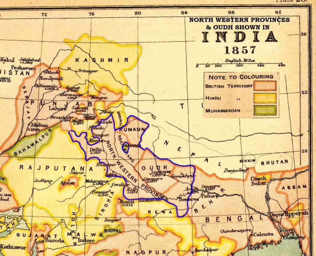
THE NORTH-WESTERN PROVINCES & OUDH
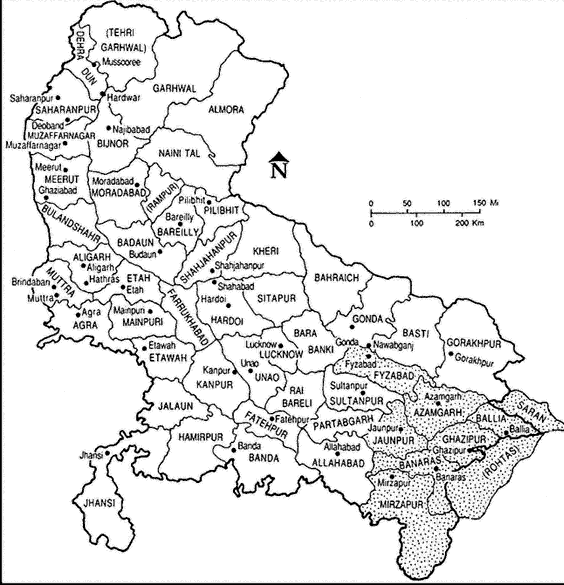
Map from: Freitag, Sandria B., editor Culture and Power in Banaras: Community, Performance, and Environment, 1800-1980. Berkeley: University of California Press, c1989 1989. http://ark.cdlib.org/ark:/13030/ft6p3007sk/
It must be mentioned here that the term “North-Western” does not actually refer by any means to the actual north-western boundary of British territory in 1857. It was simply a leftover from 1833 when the Bengal Presidency was divided, and this happened to be in the north-western area of the said Presidency. As long as Punjab had not been conquered or Oudh annexed, it did make sense — but after the conquest of Punjab in 1849-1860, the area between Bihar and Delhi to which it originally referred should have been renamed, but no one ever bothered to do so, and the name stuck as the “North-Western Provinces.” To make governing this territory somewhat easier, it was divided into several divisions, and in turn, each of these was further subdivided into districts.
The Benares Division
With an area of 2584.81 km2 and a population of nearly 900’000, the Benares Division consisted, besides the city of Benares itself, of the districts of Mirzapur, Juanpur, Gorakhpur, Ghazipur and Azamgarh. With an area of 2584.81 km2 and a population of nearly 900’000. Although an all-out mutiny in Benares itself was averted, Azamgarh and Gorakhpur would fall by June, while events would take a tragic end for a young civilian in Mirzapur in July, and Jaunpur would be called a singular disaster.
The Allahabad Division
No less of importance than Benares, the Allahabad Division included not just the city of Allahabad, but also Fatehpur, Kanpur, Banda and Hamirpur. Of Kanpur, we have already read much, and the events in that forlorn station tend to overshadow the rest of the division. However, not one of those districts was spared in 1857 and the accounts are no less harrowing.
The Agra Division
By far the most recognisable of the divisions is Agra. The city itself would be the site of another siege — but as we will see, it would not have the horrible end of Cawnpore nor the dogged daring do of Lucknow. It was just quite uncomfortable. The districts of Agra, however, would have their fair share of misery. We have already explored them in greater and lesser degrees — Farrukhabad/Fatehgarh, Mainpuri and Etawah. Mathura will be explained in some detail in another chapter, as it brings us into contact with a singular magistrate and collector, Mr. Mark Thornhill. We have already met his brothers in Cawnpore and Sitapur.
The Rohilkhand Division
Home to the districts of Bareilly, Muradabad, Bijnaur, Shahjahanpur and the Tarai Parganahs, some events have already been told — however, some more detail will be given in future instalments.
The Meerut Division
Comprising six districts — Dehra Dun, Saharanpur, Muzaffarnagar, Meerut, Bulandshahr and Aligarh — it was one of the more populous divisions in 1857, with 4.5 million inhabitants. It is where the storm broke in May 1857; it is little surprise that none of the districts would be able to restore order for some time to come.
The Delhi Division
As the events in Delhi will dominate these pages in future posts to come, it is worthwhile to note that the districts in this division will be given their fair share of recognition — Gurgaon, Hissar, Panipat and Rohtak.
The Oudh State
Annexed in 1856 under the Doctrine of Lapse, the Oudh State had all but ceased to exist — however, events moved too quickly, and there was not enough time to completely carve it up until after the mutiny was over, so it was simply called North-Western Provinces and Oudh. After 1857 it would be merged with Agra and form the United Provinces of Agra and Oudh, then in 1904 it would be a region within the United Provinces until finally ending up as the Agra Province. Under the Oudh State, we find Faizabad, Lucknow and Sitapur.
Bihar Division — Patna Division
At the time of the revolt in 1857, the Bihar Province — then known as the Patna Division — consisted of six districts: Patna, Bihar, Sharan, Shahabad, Tirhut and Champaran. Bihar was of particular concern for the EICo as both indigo and opium were prime commodities, both being grown through forced cultivation, which in turn was exploited by the planters and the zamindars alike. Events in Bihar would not begin until July, but the consequences would be felt far and wide.
